Developing the traceable measurement techniques and methods for satellite product validation and establishing Wytham Woods (Oxford, UK) as one of a network of global CEOS 'supersites'
Satellites are used extensively to monitor properties of the Earth’s vegetation, offering an effective way to obtain frequent, global measurements where ground-based measurements are not practical. Applications of these measurements range from climate, environmental and ecological monitoring, agriculture, forestry and land management.
Ideally, information derived from satellites should be validated against reference measurements (either in situ or airborne) of the same quantity, which are traceable to SI and whose uncertainties are well characterised.
Traceable end-to-end quality assessment of satellite products, that includes uncertainty characterisation of the retrieval algorithm as well as the reference (in situ or airborne) data and methods used to validate the algorithm, is critical for understanding the derived information, as well as the nuances between the wealth of similar satellite derived products that are currently available.
NPL have been working at Wytham Woods site in Oxford, UK to develop and test the methods which should be followed by the international validation community when:
This work aims to establish Wytham Woods as one of a network of global CEOS (Committee on Earth Observation Satellites) 'supersites' for Earth observation calibration and validation.
Although earth observation (EO) data and products are widely available, it is still rare for them to have reliable and fully traceable (ideally to SI) evidence concerning the quality of the retrieved information. Quantitative EO products can be compared against calibrated in situ measurements such as those from reference networks (RadCalNet (CEOS 2019), Aeronet (Holben et al. 1998)), through intensive field campaigns ( BigFoot (Cohen and Justice 1999), VALERI (Baret et al. 2005)), or ecological research networks (TERN (Karan et al. 2016), NEON (Keller et al. 2008)). However, in most cases (excluding RadCalNet) the field campaigns or networks were not implemented with the primary purpose of satellite product validation studies, but rather only to understand local or continental-scale ecological processes and land-atmosphere interactions.
Consistency of measurements of the same parameter taken at individual sites by different teams cannot be guaranteed. So spatial sampling and measurement equipment may differ and operator and post-processing errors are not typically quantified. In addition, the array of satellite-derived data products being validated are often created with multiple sources of EO data using different retrieval algorithms and assumptions. These confounding issues mean that estimating a meaningful bias between the in situ ’validation‘ measurements and the satellite observations is challenging.
Reliable compliance information of quantitative EO products will become even more critical as satellite-derived data are increasingly driving the information and knowledge required for decision making. Compliance and quality information will serve to solve issues that may arise around:
1. regulatory initiatives
2. liability debates between customers and providers of value-added (quantitative) EO products and services
3. auditing efforts and/or contractual negotiations for the operational exploitation of EO data (Widlowski 2015).
Irrespective of context, the conformity of a data product can only be established with respect to permissible deviations from an agreed reference, eitherin situ or drone-based estimate of the satellite derived variable. Ideally this reference should be SI traceable,or community agreed, and the uncertainty of the reference will be smaller than that of the candidate item. While these considerations are an integral part of conformity testing in metrology, they are not yet included in validation efforts of satellite-derived quantitative surface information (Widlowski 2015).
In simple terms, the ESA sponsored Fiducial Reference Measurement (FRM) programme aims to provide a suite of reference measurements (of land, ocean and atmosphere variables) with an associated uncertainty that can be used to conduct satellite product validation through conformity testing. That is, the process that determines whether the estimated target quantity (i.e. the satellite estimate) falls within the range of tolerable values (i.e. the reference estimate), or not.
Further, FRM4Veg will develop the methods and guidance documentation which should be followed by the international validation community when a) collecting both campaign and permanent FRMs, and b) performing validation of satellite derived products, over the vegetated land surface.
All FRMs should:
1. Have documented SI traceability (or conform to appropriate international community standards), utilising instruments that have been characterised using metrological standards, both pre-deployment and evaluated regularly post-deployment (Fox and Greening 2010, Theocharous et al. 2010).
2. Be independent from the satellite geophysical retrieval process.
3. Be accompanied by an uncertainty budget for all instruments, derived measurements and validation methods (JGCM-100 2008).
4. Adhere to community-agreed, published and openly-available measurement protocols/ procedures and management practices. 5. Be accessible to other researchers allowing independent verification of processing systems.
FRM4Veg field sites include: Wytham Woods, UK and Barrax – Las Tiesas, Spain
Additional field sites are being considered for FRM4Veg phase 2 that will commence in 2020.
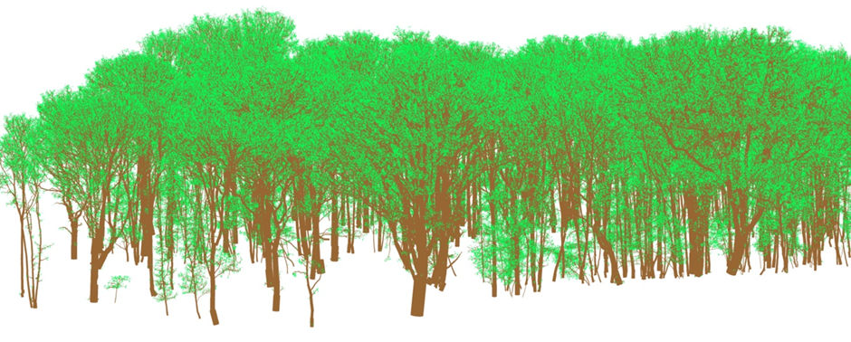
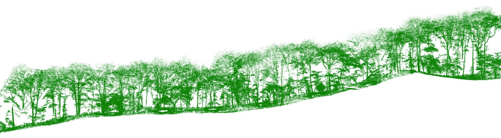
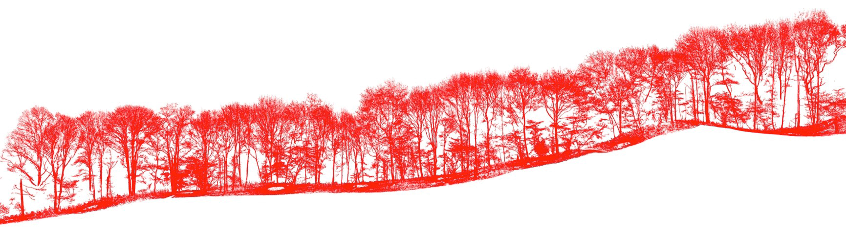
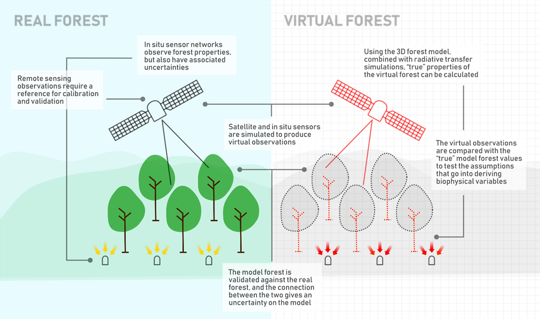
The Wytham Woods 3D model was developed in order to aid the validation of satellite biophysical products by allowing users to test the assumptions associated with their associated processing chains. The model uses terrestrial laser scanning (TLS) data as the basis for the 3D information, and spectral reflectance measurements as the basis for the radiometric information associated with the forest constituents (such as leaves, bark andsoil). The structural components, derived from the TLS data, are built using the quantitative structure modelling (QSM) approach developed by Raumonen et al. (2013). The leaves are added according to the leaf area index (LAI) estimated using the TLS leaf-on data and the algorithm given in Åkerblom et al. (2018).
The model is described in detail in Calders et al. (2018). It is based on data from summer and winter field campaigns conducted in 2015.
Leaf-on >> leaf-addition
Leaf-off >> tree architecture
Wytham Woods test site in 2021 as part of further EMRP grant funding. The 2021 rescan and new model will enable additional exciting research into model validation and change detection at the site.
The Wytham Woods 3D model was developed by NPL and funded through the Metrology for Earth Observation and Climate project (MetEOC-2), grant number ENV55 within the European Metrology Research Programme (EMRP). The EMRP is jointly funded by the EMRP participating countries within EURAMET and the European Union.
Please note, our data is free and open access. However, we do kindly ask if you use the data that you reference the source appropriately.
The fraction of absorbed photosynthetically active radiation (fAPAR) is a key parameter in photosynthesis models which inform our understanding of the productivity of vegetation as well as its ability to absorb light and water. Satellites routinely estimate fAPAR from space. Due to the varied nature of the reflectance models that underpin the retrieval of fAPAR from satellites, agreement between different fAPAR products is not common. As such, validation of the output products is required.
At NPL we have created a PAR network which is capable of estimating various types of fAPAR Widlowski, 2010. The network involves placing PAR sensors above and below the canopy to measure the incoming and outgoing PAR at that location. A key component of the data coming out of the PAR network is that it is traceable to the SI and has associated uncertainties. This is done by calibrating and characterising the sensors before they are deployed in the field.
An example of the fAPAR retrieved from the network is shown here:
The primary role of the 3D model was to serve as a validation tool. Since satellite retrievals of fAPAR are dependent on a reflectance model, the choice of model and conditions are related to the definition of that specific fAPAR. As such, in order to compare different fAPAR quantities we require a means of normalising these differences. Using the Wytham Woods 3D model and a radiative transfer model (RTM) we are able to allocate a bias associated with each assumption made in the reflectance model. This allows us to validate the fAPAR products fully, as shown graphically below.
Our research and measurement solutions support innovation and product development. We work with companies to deliver business advantage and commercial success.
Contact our Customer Services team on +44 20 8943 7070